Home Creators Posts Import Register Favorites Logout

Content

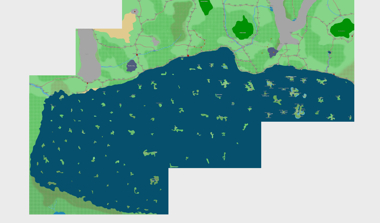
This lovely map was made for me by the very kind person over at German DnD Maps: https://www.patreon.com/germandndmaps

So what is this, and why do we have it?

This is a modern rendition of an old map that hasn't been seen since Misscliks Pirate Edition. We're getting an updated version because, if all goes well, some PCs in some not too distant campaigns will be playing in the area!

To make this map, I provided the old version and then gave a little direction to our wonderful mapper who mostly ran unaided with ideas.

The first thing you'll notice, aside from the sepia tone, is that the islands have been massively rearranged, much to our benefit. The old island were haphazard and too evenly spaced out. The new islands (which have a lot of the same shapes, names, and towns) are more thoughtfully, carefully, and intelligently placed.

The next thing is probably the huge jungle with massive rivers flowing through it. This area is mostly unlabeled and probably unexplored by civilized folks.

It's quite rare that I hand sections of world-building over non-players, and I think German D&D Maps did a fantastic job with the project. Looking at it, I see all sorts of potential, and I have dozens of ideas for what to do in this area.

What I want to know, though, is what you think are interesting features, what areas look like they have deep-lore attached to them, what zones look like certain doom, and what regions look like fun. Getting some insight into how the viewers/community process map information would be very useful to the overall story-building process.

gl hfNeal / Koibu

p.s. Shout out again to https://www.patreon.com/germandndmaps

Files
Comments

WhattaThings

I think the mouth of the bay seems extremely interesting. This ought to have been massively important to control throughout history. Similar to something like the straight of Gibraltar in our real world, or even the Malacca straight (though smaller scale than either). The two peninsulas that jut out must have some kind of ancient powerful forts located on them at some point of history and surely many battles fought over control of these entry points. Whoever controls the opening, controls the bay! There being islands in the middle even further puts this idea in my mind. If I was looking for ancient or current day power all the same, I'd dig around on those islands!

Gabriel

Wow! This map does an amazing job of showing the giant scale of Solum. That giant forest feels like it could be home to some crazy stuff. As far as interesting features go, my eyes immediately go towards the clumps of dense forest. Especially the ones surrounded by roads and cities. Gives off civilization vs untamed nature type vibes, which I really enjoy in fantasy stories.

Terri Morgan/Liefste Luna

Immediately interesting to me are relatively isolated places at curious landmarks like Farwyn isle, those sneaky little cities on that peninsula on the west coast, the two little nodes around the lake south of the jungle, and Mrah Zaheed in the north at the base of a mountain for some curious reason (and Ull's mountain passage (?) leading up to it). Most of the island groups look as though they were broken off from the main landmass, or segmented through flooding, so it seems interesting to explore what may have caused this flood or break, and what might still connect these islands, culturally or mysteriously. The chain of islands making up the entrance/exit of the bay are strategically interesting though there are notably no cities right on the tips there, which makes me wonder if the strait there might contain some 'doom' in disallowing ease of naval access. Maybe it becomes more important if some new trading partner or overseas threat is found. The deltas of large river systems feeding into (out of?) the bay are quite interesting as well given their importance to inland trade, and we see Valis/Redstone Port take advantage of that along the Great Wash, but not so much on the perhaps more pivotal Aldun River system near Fortridge in the west - which looks like a very interesting area; given the vast jungle there it makes me think of it being an origin point for expeditions/explorers/pioneers, and it also sits at the edge of the area to its north enclosed by mountains (and who knows what those have contained over the aeons). The meeting of multiple very disparate 'roads', at the edge of civilization. There are a bunch of islands with deep protected bays/coves of their own (a bay within a bay!) like around Astaron/Torus/Beggar's Cove, which always make me wonder what sort of secretive stuff may take place there. Lastly.. there's some cool names I wanna know the history behind; Nightingale's Crossing, Dragon Glass Lake, Black Crown Port, Rak'Gorp/Kaa'Rorgh, & Hall of Heroes.

Adam C

I know they’re all likely of little importance but these little speck islands that surround the proper islands that are probably only a mile or two wide at best. Too small to support life or civilization but the perfect size to sink ships in the night or hide something you don’t want found.

Joel Martensson

Hello Neal! I just found this map trough reddit. I love it! I am however wondering if there exists a unlabeld version? That I could buy. Just to clearfy im fine with the roads and city locations just dont want the names. Thanks in advance. Have a great summer! Much love, Joel