Home

 Creators
 Search
 Recent
 Missing
 Random
 Posts
 DMs
 Tags
 Random
 Importer
 Import
 FAQ
 Account
 Register
 Login
 Favorites
 Keys
 Logout
 Telegram

Navigation, trade and civilization on Africa's second Nile: a history of the Niger River (Patreon)
Content
"there appeared to be twice as much traffic going forward here [on the Lower Niger] as in the upper parts of the Rhine, the whole population on the Niger being eminently of a commercial character"
Laird Macgregor, 1832
The Niger river was a central element in the political economy of west Africa and the control of this vital waterway has for centuries been inextricably linked to the success of many west African states. Measuring 4,180 km --of which over 90% was navigable using massive cargo barges-- the Niger is arguably the longest navigable river in history.
From the empire of Mali to the trading states of its lower delta, the Niger provided a corridor that united the mainland kingdoms and cities of west Africa across vast ecological zones, into to an intricate hydrographic system that was ultimately connected to the Atlantic.
The riparian populations along the river's banks excelled at boat-building and riverine travel, constructing massive barges whose capacity to carry people and their merchandise across vast distances rivaled that of medium-sized ocean-going ships. Although there were three rapids at intervals of about a thousand kilometers that briefly interrupted navigation, each section of the Niger divided by the rapids constituted a veritable highway in a complementary transport system that linked overland and riverine trade routes, and created strategic convergence points were vibrant trading cities were established.
An indication of the significance of the river system to the geography of west Africa is revealed by the fact that many external writers and some west African scholars regarded the rivers of Niger and Senegal as part of a single complex system - the "Nile of the Sudan". Which, despite the misnomer, accurately reflected the Niger's significance to west African civilizations; just as much as the Nile was the 'lifeblood of Egypt'.
This article explores the history of Navigation, trade and civilization on the Niger: It includes a detailed description about riverine traffic along each section of the river as well as the political and social groups associated with it; It then looks at the economic history of two of the Niger's busiest sections in Mali and Nigeria, and ends with answers the questions of whether Africans mapped and explored the Niger.
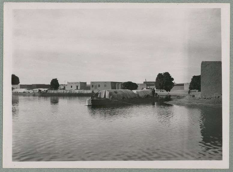
barge on Timbuktu's river port of Kabara, ca. 1930-1939, the largest of these vessels had a capacity of 90 tons
A Brief description of the Niger river.
The Niger (pronounced: Ni-Jer ) is the third longest river in Africa. it begins in Guinea, not far from the Atlantic coast, and runs north-eastwards through Mali, before turning sharply south-east through Niger and Nigeria.
Its course can be divided into four major sections; the Upper section which ends at the Sotuba rapids, the Middle section (from the inland Niger delta to Niger Bend) which ends at the Fafa rapids, the Eastern section which ends at the Bussa rapids, and the Lower Niger Basin which pours into the Atlantic.
Navigation using large, flat-bottommed and sheltered cargo-barges, is possible for virtually the entire length of the Niger for at least the entire second half the year. The following paragraphs combine information about the present state of riverine traffic (see; The Niger River Basin pg 19, Traditional use pg 118), as well as historical documentation provided below.
Beginning in the Niger delta, barge navigation is possible throughout the year upto Onitsha (1,127km from the ocean). Its then possible for most of the second half of the year (August to February) upto Jebba. The stretch between Jebba to the Bussa rapids, and from the Bussa rapids to Yelwa is only navigable by canoe. But from Yelwa through Niamey to Tillabery/Sinder, the river is navigable by barge between August and February until the section just before Fafa rapids. After the Fafa rapids, barge navigation is again possible for nearly the whole year from Gao to Timbuktu's ports of Koriomé and Kabara.
For the entire stretch from Timbuktu to Mopti and Djenne, barge navigation is possible from August to February. From Mopti and djenne to Segou and Kolikoro, barge navigation is possible from July to December. Between Koulikoro and Bamako are the rapids of Sotuba but these are traversable even by barges . And starting at Bamako, barge navigation resumes all the way upstream upto the Kouroussa and Kankan on the Niger's tributaries.
This is the course shown in the map above, the following headings will explore each section .
A history of Riverine navigation in the Upper Niger's tributaries from Kankan through the Sotuba rapids, down to Jenne: Mali traditions and the Somono ferrymen.
Map showing the upper Niger river section and its tributaries
The histories of the riparian populations on the Niger were closely intertwined by the political and social history of west African empires throughout the centuries. The role of the Somono in the Upper Niger during the empires of Mali in the 14th century, as well as Segu and Tukolor in the 18th and 19th century, is particularly important in understanding the history of navigation along the Upper Niger's tributaries. Their history and role in riverine traffic of the Upper Niger is mirrored by that of the Sorko in the middle Niger region, that will be looked at below.
(Somono Bala of the Upper Niger pg 52)
In the upper Niger, one of the most pressing demands for the elites seeking to extend their control over the region was for a body of professional ferrymen. This role was filled by the Somono who were comprised of various ethnic groups including the Soninke, Bambara, Malinke and Bozo. While the organization of this enigmatic corporate-ethnic group is best known during the 18th century empire of Segu, its roots have been convincingly argued to have begun during the era of Imperial Mali. Mande traditions hold that the aristocratic keita lineages of Mali gave the river rights of the section between Kangaba to Kolikoro, and from Kolikoro to Mopti, to the ancestors of the Somono ferrymen.
(Somono Bala of the Upper Niger pg 15-21)
After the fall of Mali in the 16th century, the empires of Segu, Massina and Tukolor dominated the upper Niger region and came to rely on the Somono's riverine expertise even more than Mali's rulers had. For example, in return for new recruits and exclusive rights to navigate and fish the river, the Somono paid a special tax directly to the Segu kings in cowries, fish and other trade items acquired upstream. These items often came from European merchants upstream at towns such as Kankan and Kourussa where they'd been brought overland. The Somono provided a ferry service for the movement of personnel and information, they hauled goods and armies from the Segu and Mopti upstream, and they provided labour for construction and repair of public buildings and walls in Segu.
(Somono Bala of the Upper Niger pg 7-10)
Through the growing number of recruits and permeable social identity, the Somono established settlements at regular intervals along the Niger to facilitate intrastate communications. The explorer Mage and Quiton described such a network; "Each of our canoes received a skipper and two crew members at Nyamina … at each village, one gets a new crew which thus relays from station to station. This service was organized by El-Had Umar (of Tukolor) for his needs, and had existed since the creation of the Somonos"
(warriors, merchants, pg 69- 71)
While the section of the Upper Niger dominated by the Somono may appear to have been divided by the rapids at Sotuba, according to Mungo Park, these were not an insurmountable barrier. He writes that "The King of Bambarra's canoes, however, frequently pass these rapids, by keeping close to the bank ; persons being stationed on the shore with ropes fastened to the canoe, while others push it forward with long poles."
(Travels in the interior of Africa districts of Africa pg 231)
The Bambara canoes observed at Segu by Mungo park were said to be very long and relatively narrow. They were formed by sewing two hallowed out trees trunks end to end, but these trees must have been very large for he adds that "they are, however, very roomy ; for I observed in one of them four horses, and several people crossing over the river", this gives them a capacity of 2-3 tons. But these particular canoes were specifically used for river crossing by professional Somono ferrymen, and are unlikely to have been the same that were used in Long distance trade; especially since Park also mentions that they had no decks or mattings, but later describes seeing much "large canoes" full of cargo that were covered with mattings. He also adds that the town of Kancaba (Kangaba) was supplied with merchandise from Segu via "large canoes" sent upstream, presumably about the size of those he'd seen at Segu or even larger.
(Travels in the interior districts of Africa pg 191-192, 199, 250, 310)
In his 18th century account about his river trip from Kolikoro (right after the Sotuba rapids) to Nyamina, Mungo park travelled in 6 large canoes granted to him by the griot of the king of Segu to carry all his baggage. He mentioned that the canoes were large enough to sleep in, which they did for security reasons after having made a brief stop-over at a Somono village on the banks of the river. He mentions that these particularly large boats were built in the town of Kankaree, where there's good mahogany wood for boat-building, and where all the Bambara canoes of Segu came from. He also includes a sketch map of the river's course from Djenne to Timbuktu drawn for him by a Somono ferryman who had travelled the route several times.
(The journal of a mission pg 146-149)
(map on the left) "sketch of the course of the Niger, made by an old Somonie, who had been seven times at Tombuctoo"
(map on the right) the middle Niger river between Jenne and Timbuktu
Mungo Park's observations about the navigability of the Niger upto Kankan were confirmed by Rene Caillie in the 1820s who observed that the Milo (Niger's tributary at Kankan) " is broad, deep and fit for the navigation of canoes, drawing six or seven feet water". He too was carried in a type of sewed canoe suited for the upstream trade, being about 50 feet long but narrow, and was able to carry his baggage including animals. He also observes about the Sotuba rapids that "canoes can descend and ascend by a tow-line without even discharging their cargoes"
(Travels through central Africa pg 280, 286-287, 284)
Its therefore certain that the Upper Niger region constituted a fairly navigable route whose control was not only central to the success of west Africa's empires, but also to the region's economies. It was at the heart of the dynamic overland-riverine trade whereby shrewd local merchants could switch exports to and from the Atlantic using of the river and overland systems to make the best of market opportunities, especially during the 18th and 19th centuries as we shall explore later.
The documented riverine route controlled by the Somono ferrymen during the 18th and 19th century.
The documented riverine route controlled by the Somono ferrymen during the 18th and 19th century.
The town of Kolikoro near the Sotuba rapids, ca. 1925
Large canoe on the Niger near Segu, ca. 1935, quai branly
A history of riverine Navigation in the middle Niger from Jenne to Gao: 17th century Timbuktu chronicles and the Sorko ferrymen of Songhai.
Map of the middle Niger region
Riverine activity along the middle Niger first appears in external accounts from the 11th century. As al-Bakrī reports in 1068, fishermen (presumably the Sorko) from the Niger bend region were carrying merchants and merchandise along the river section between a town called Ras-el-Ma (located near Timbuktu) and the city of Gao.
(The canoe in west African history pg 523, Arab knowledge of the Niger's course pg 86)
Gao was at the time the capital of a large kingdom called Kawkaw, which controlled the eastern Niger at Bentyia/Kukiya that we will explore later
The Sorko who are mentioned above are Songhay-speaking masters of the water, monopolizing river transportation over the entire section of the Middle and Eastern Niger from atleast Djenne upto the region of Dendi and Kebbi in the border between Benin/Niger/Nigeria. They are amongst the earliest inhabitants of the Middle Niger possibly originating in the inland delta region but retreated into the eastern Niger section's tributaries where they would have been able to find trees sufficiently large to build boats. They were dependents of the Askiyas (rulers) of Songhai empire, and were in charge of ferrying the rice and other grain to Gao, that had been harvested in the royal plantations along the river banks.
(Timbuktu and Songhay pg xxx, African dominion pg 340-341)
The Sorko would have also been in charge of ferrying the soldiers and messengers of the empire. The fleet was under the command of the Hi-Koy (“Chief of Boats”, i.e. Chief of River Transportation), one of the highest officers in the Songhai empire. Further importance of controlling riverine traffic, especially at Timbuktu, can be gleaned from the offices of The Kabara-farma and Balma'a (both inherited from Mali). The Kabara-farma was in charge of levying duties on all boats arriving and departing from Kabara, while the Balma'a was also stationed at Kabara (the river port of Timbuktu), but as the military commander.
( Bentyia/Kukiya pg 16, Timbuktu and Songhay pg 169, n.5)
The Sorko were also documented to have ferried the Askiya and many of the Songhai elites at Gao, downstream to the region of Dendi after Songhai's defeat by the Morrocans in 1591. For this role, there was the Goima-koi, master of the habour at Gao, who gathered 400 kanta (royal barges) and 1,700 other boats belonging to the rest of the non-ruling royals, and managed to get them across the river. It's unclear if the entire crossing was made overland, but it's more likely that it was made by river, since the Askiya would then establish his new capital at Dendi on the left bank of the river. The Moroccans would also learn how to utilize barges to sail downstream so they can attack Dendi and build a fort at Kulani, although they'd quickly evacuate it after the Askiya's flotillas kept harassing it.
(Timbuktu and Songhay pg 190, n.29, 196, 222)
The Sorko barges used by the Askiyas of Songhai were known as Kanta, being named after the region of Kebbi where they were built and/or where their crewmen originated --somewhere along the eastern Niger's banks. The Songhai rulers had their heartlands in this eastern Niger region between Bentyia/Kukiya and Dendi, and it's here that they established their largest rice estates to provision their palaces at Gao. They also established plantations along the middle Niger at Kiyusu (between Timbuktu and Gundam), on the isles of Bamba and Benga (in the lacustrine area itself), at Ataram (to the west of Baghana), at Kaniaga, and along the western and eastern banks of lake Debo. The Sorko barges could each carry upto 20-30 tons of cargo harvested from these estates and send it by river to Gao. This tantalizing figure taken from the 17th century Timbuktu chronicles, would later be confirmed by explorer accounts.
(Timbuktu and Songhay pg Islam pg xxxi, li, 304 n.38, African Dominion pg 341-342)
There are frequent mentions of the usage of riverine transport in political contexts of Songhai. The use of riverine warfare (eg at Djenne and Timbuktu), canals (eg at Kabara and Lake Faguibine), and professional Sorko ferrymen (from Dendi), was extensively documented during the Songhai campaigns, especially during Sunni Ali's conquests. Even after Sunni Ali, the Niger remained the primary means of transporting armies across the vast empire, and there are some explicit mentions of this. In 1529, a prince named Uthman Yawbabo went to meet his newly installed brother Askiya Musa at Gao by river, so he loaded his boats and forces onto many barges. But while sailing, he was initially prevented from going further by his griot, who mocked him for accepting his brother's coup. So he turned around his forces to re-strategize, and later formed an alliance and sent his forces downstream again to Gao. But they were intercepted and defeated by the Askiya's forces near Kabara, who'd likely arrived by river from Gao as well.
(African dominion pg 188, 190-191, Timbuktu and Songhay pg 34, 119-120)
There are also mentions of riverine trade, albeit brief ones, between Jenne and Timbuktu. The earliest was when an emissary of a deposed Askiya Muhammad Bonkana arrived at Timbuktu in around 1538 from a trading mission to jenne with a boatload of cargo for the Askiya that included Kola-nut. The deposed Askiya instructed the emissary to continue to Gao. And the second being Qadi Mami who, in around 1592, sold two boatloads of salt in Jenne that he had brought from Timbuktu, for a huge profit, because the upheaval of the Moroccan wars had cut off the trade.
(Timbuktu and songhay pg 212)
In all documented accounts about riverine transport along the Middle Niger, the use of massive barges begins around Djenne and extends northwards to Kabara and Gao, upto the Fafa rapids at Bentyia/Kukiya. The region of Djenne would also mark the limit of the riparian groups of the Somono and the Sorko.
The explorer Rene Caillie provides the most detailed account about the Barges employed in the riverine trade of the Middle Niger in the 1820s. Rene's account clearly contrasts the "large canoes" which he saw at a village a few kilometers upstream of Djenne with the narrow canoes he had mentioned earlier at Kankan. He later encounters these same canoes at Djenne itself, writing that he "was astonished at the size of these canoes". After informing the local authorities of his intention to travel to Timbuktu, he was allowed to board one of these large canoes with a capacity of 15 tons, after booking a space for 300 cowries complete with sleeping space. But this canoe was considered small in djenne, for he would later be conveyed onto a much bigger one.
(Travels Through Central Africa pg 441, 444-445, 474-475)
At a port called Coona, he was conveyed onto a massive canoe, with a capacity of 60 tons and was sheltered with matting. He observed that there were always about flotillas of 80 such barges plying the route between jenne and Timbuktu. Each had a capacity of 60-80 tons, measured about 100ft long and 12-14ft broad, with a crew of 16-18 including the captain, and could accommodate more than 50 other passengers alongside animals. These barges are made by stitching large planks together at the side using a rope, and the stitching holes are caulked with a local binding concoction. Wooden bars are laid at the bottom but leave a trough in the middle from where leaking water is bailed. Other wooden bars are raised to form a 3ft high deck, and there was a section for cooking as well as enough room for bailers to work in 6hour shifts, and for the crew to move around the barge for it was steered with poles and paddles and required to be maneuvered.
(Travels through central Africa Vol. 2, pg 5, 9-12)
The rest of his journey until Timbuktu's port of Kabara is spent describing his experience with the canoe ride and seeing several flotillas with even bigger canoes. He also recommended further exploration down the river after being informed by a Timbuktu merchant that the Niger could be navigated downstream by large canoe to Hausa territory (Kebbi) in 20 days, and further until the delta.
(Travels through central Africa Vol. 2 85-86)
There is therefore extensive documentation about the use of the Middle Niger river section for transport in all contexts, on massive barges whose capacity rivalled that of most medium sized ocean-going vessels.
Map of the Middle Niger river section controlled by Sorko ferrymen between the 16th and 19th century.
barge on Timbuktu's river port of Kabara, ca. 1930-1939, quai branly
Barge on Timbuktu's river port of Koriomé, ca. 1903, quai branly
A history of riverine Navigation along the Eastern Niger section between the Fafa rapids at Bentyia, upto Dendi: From the Songhai empire to 19th century accounts.
Map of the Eastern Niger river
The region between the Fafa rapids and Labbezanga rapids was home to the historic urban settlements of Bentyia/Kukyia which occupied an incongruous place in the history of Songhay speakers and the empire of Songhai. Their strategic location at the rapids was such that traders travelling downstream would need to unload their vessels at Bentyia and arrange for the overland transportation of their goods beyond the rapids, while those coming upstream would resume riverine transportation at Bentyia.
(Bentyia/Kukiya, pg 6)
Bentyia is referred to in the Timbuktu chronicles as Kukyia. It was home to several urban settlements since the late 1st millennium BC and early 1st millennium AD, but acquired a monumental character in the late 1st millennium AD-1200 and 1200 AD to c. 1600 AD, with palaces and inscribed tombstones, during a period coinciding with when it was the seat of the Gao kingdom and later the early Songhai empire under Sunni Ali (1464-1492). Alluvial gold from Daargol and Sirba (south of Tilaberi) was exported via river upstream to Kukiya, and it's also from here that Songhay armies would campaign extensively downstream into Borgu, the Husalands (at Kebbi), and as far as Bussa (near the rapids) during the 16th century.
(Bentyia/Kukiya, pg 7-9, 21)
These campaigns would have doubtless involved the use of large canoes similar to those mentioned above during Sunni Ali's conquests. But while it's unclear what the capacity of these war canoes were, there's little doubt that the barges referred to earlier that were bringing 20 tons of rice from the royal plantations in Dendi, certainly travelled from the eastern section of the Niger, just as much as they did from the Middle section. The farms were located at Irya (downstream from Dendi), then Dendi, Kulani (in the Niamey-Say area), Karai Hauṣa and Karai Gurma (left and right banks of the Niger), then lands around Gao and Kukiya.
(African dominion pg 340-342)
Dendi would be where the Askiyas fled after the fall of Songhai, and the Askiyas consistently sent fleets along the Niger river to harass Moroccan positions and between 1604-1617, they retook vast swathes of Songhai territory upto Jenne and Massina, cutting off the Moroccans garrisoned at Timbuktu and Gao. But documentation of riverine traffic and other activities between Dendi and Gao would decline after the 17th century.
(Muslim traders, Songhai warriors, pg 76-77)
The eastern river would nevertheless retain its significance as a trade conduit, only this time on a localised scale, as evidenced by the accounts of the explorer Heinrich Barth who reached the region around 1850. In his description of the Niger river town of Say, Barth noted the canoes used by the local Fulani and Songhay traders were 40ft long, 5ft wide and were of "good size", "consisting of two trunks of trees hollowed out and sewn together in the center". The canoes carried three of his camels, and needed little bailing. This boat building style and relatively low capacity (about 2 tons) recalls that which was used by the Somono's river crossing in mentioned by Mungo Park in the upper Niger's tributaries. However, it more likely reflects the low volume of trade during this time rather than the inability of the river to allow the type of larger watercraft used in the same region by the Askiyas centuries earlier.
These canoes were sent by the "king of the waters"/"inspector of the harbour" thus indicating the importance of the Niger in local administration, and they were "chiefly employed for conveying the corn from the town of Sinder, which lies higher up the river, to the town of Say". He adds that every food provision in Say, such as grain, rice, was supplied from Sinder and that the riverine trade between Kandadji (near Sinder/Tillabéri) and Kirotashi (15miles south of Say) is not inconsiderable but depends a lot on political circumstances. He concludes that Say is an important place on this tract of the river for Europeans in the Niger delta who wish to trade upstream, if only they could cross the rapids between Busa and Yauri (Yelwa).
(Travels and Discoveries in North and Central Africa pg 380-387)
Barth's account doubtlessly reveals that the agricultural plantations established during the Songhai era had persisted in the 19th century, albeit at a reduced scale that reflected the political and economic realities of the period after Songhai's collapse. So the Niger was navigable throughout this section from the rapids down to Dendi. But these region just downstream from Dendi was the limit of Songhai's estates as we described in the Timbuktu chronicles, so we turn to 19th century accounts to see how navigable the rest of the river was down to the Bussa rapids.
Navigable sections of the Eastern Niger upto Dendi as documented in 17th century chronicles and 19th century explorer accounts.
The Eastern Niger river section between Dendi, through Ilo and Yelwa, upto the Bussa rapids: 19th century accounts and local traditions.
Detail of the Eastern Niger river between Dendi and Bussa upto Rabba.
An account by joseph Toutee in 1897 while at the town of Ilo, mentions “big canoes of a very special manufacture" which he obtained from the King of Bussa. He also adds that; “The people of Ilo are, like those of Boussa, remarkable boatmen, and although the calm of their waters has not given them the opportunity to acquire to the same degree the qualities of coolness and intrepidity of their brothers installed on the fast, we might find there more inland waterway resources than in Boussa itself. This is because there is a forest near Ilo trees with very hard wood, very favorable for the construction of canoes. The type of large canoes that I encountered in Boussa and which circulates from Saye [Say] to Rabba, is indeed from Ilo. These canoes easily carry from three to five tons, and they require for their construction a consummate personal skill on the part of of the carpenter. In France there are not four out of a hundred art workers who are capable of such work. This industry is less developed in Boussa, where it is recently imported”
(Two thousand years in Dendi pg 13 n.92)
Besides confirming that the Bussa rapids didn't impede the spread of building barges and their use south of Ilo it also confirms the definitive use of Barges in much of the upstream section from Say to Ilo. This is further affirmed by the traditions about the Turuwe, who controlled the waterway between Kompa and the ancient site of Birni lafya in northern Benin (located near Gaya on the above map). Their main activity was providing river crossings to people and to caravans in large canoes that could transport everything including donkeys, and they held this monopoly because other groups in the area only used small fishing canoes. The Kumate are a Soninke diaspora that came to northern Benin sometime between the fall of Mali and Songhai and boatbuilding was one of their main professions, a craft they would have undoubtedly acquired from their homeland in the Niger delta region.
( Two Thousand Years in Dendi pg 13-14, 300-304)
Map showing sites associated with the Turuwe's riverine activities
The above accounts confirm that Ilo was the likely origin of the barges used by the Sorko ferrymen of Songhai in the territory of the Kebbi kingdom, ie; somewhere along the eastern length of the Niger between Dendi and Yelwa. The relative differences in watercraft capacity in the 19th century Eastern Niger versus earlier periods, could be attributed to both; the low level of trade and the lack of large enough trees as was hinted at by Toutee and as we shall explore below . But while the Sorko people who are associated with large barges would have crossed the Bussa rapids south of Yelwa, there's less evidence that their barges came with them.
There's little doubt that the nearly 80km long section of the Bussa rapids presented a significant challenge to riverine traffic between areas north of Yelwa, and those south of jebba and Rabba, save for relatively small, maneuverable canoes. As Barth had observed in 1854 about the Bussa stretch, there was a need to blow up certain rocks "which most obstructed the navigation between Yauri and Busa" .And there were many attempts by explorers to cross the rapids, especially following the death of Mungo Park in this exact region. While the brothers Richard and John Lander were successful in sailing down the river in 1830 using a local canoe, later explorers like William Baikie in 1857 ran aground upstream of Jebba in a steamer, and another named Glover failed to guide a local canoe upstream from jebba, being forced to travel on foot to Bussa.
(Human Adjustment to Kainji reservoir pg 3-5)
Map showing the region of the Bussa rapids before construction of the Dam in 1964
However, since west African transport often used complementary systems of riverine and overland travel, there's evidence for the extension of the Sorko diaspora into the Yauri kingdom (Yelwa) and down the Bussa rapids as recorded in traditions collected by P.G Harris in 1930. These Sorko ferrymen controlled a significant riverine trade that extended downstream to Jebba and even further downstream the lower Niger towns of Lokoja, Onitsha. The Sorko mostly traded agricultural products like rice, onions, beans and shea butter, in exchange for salt. The canoes built by the Sorko in Yauri consisted of two kinds, the "kwolli kwolli" and the "ukwami". Both of these canoes are sewn, but unlike their peers upstream who sew planks together to make a barge, the canoes are sewn to make longer boats of what are essentially two ends of a dug-out canoe joined at the center. The "ukwami" being the longer and relatively larger canoe, is used for long-distance trade.
(Notes on Yauri, pg 308-10)
This Sorko diaspora had doubtless been established along the Bussa rapids before the 19th century. According to Lander's observation, the canoe that he was given at Bussa to sail down the rapids was of not as well made as to those he was used to seeing in the delta region, and he attributes this to the "want of proper trees of sufficient magnitude" . This indicates that these canoes weren't the large ones built at Ilo but rather local ones specifically used in the Bussa region. He writes that "the canoes are of great length … they are made of two blocks of wood, which are sown together by a thick cord". But unlike the massive barges that have been described earlier for all sections of the Niger, the canoes of Bussa could not carry horses because the animal's weight exceeded their capacity. This leaves little doubt that the canoe given to lander was the "ukwami" type; it being sewn, relatively long, used for long-distance riverine travel, but had a relatively low capacity.
(The Niger Journal of Richard and John Lander pg 122)
There's therefore evidence for a significant riverine traffic between Dendi and Yelwa, as well as boat-building in Ilo, and for much of the lower section of the Eastern Niger terminating at Bussa. But the region of the Bussa rapids itself in the section between Yelwa and Jebba would have constituted the only length of the Niger that cannot be considered navigable by any type of large watercraft.
Map showing the navigable section between Dendi and Yelwa, and from Yelwa to Jebba
A history of Navigation in the lower Niger river section between Bussa/Jebba to the lower delta region at Bonny.
Detail of map showing the political landscape of the lower Niger river in the late 18th century. Highlighting the most important river towns mentioned in this text.
The lower delta region was home to several polities. The states of Warri (Itsekiri), Brass, Bonny, New Calabar and Okrika were moderate-sized polities centered around capitals located within the delta or at its coast. The ecological environment of the delta, which was not well suited for the growth of a number of crops nor raising most animals, compelled the inhabitants of the region to trade upstream. It's for this reason that "canoes provide the sole means of transport through the Niger Delta, and without it there can be no trade".
Traditions of the kingdom of Brass (Nembe) mention that their canoes often sailed as far as Ibo kingdom of Aboh, to Onitsha, and even beyond, to the Igala kingdom of Idah, from where they obtained yams and cattle.
(Long distance trade pg 320-323)
According to Duarte Pacheco in 1506, the canoes in the Niger Delta (between Bonny and New Calabar) were the "largest in the Ethiopias of Guinea; some of them large enough to hold eighty men, and they come from a hundred leagues or more up this river bringing yams in large quantities; they also bring many slaves, cows, goats, and sheep."These mostly agricultural products -as well as cloth from the Ijebu, were exchanged with delta products especially salt and other merchandise, the former of which soon became a major currency in the inland states along the Niger's banks.
(A theory of the canoe house pg 153, Long distance trade pg 325-328)
Describing the same canoes in the 17th century, Olfert Dapper states that they were 70ft long and 8 ft wide, fitted with benches for atleast 20 rowers and could carry 80 passengers, as well as trade commodities including yams, palm oil, bananas, deer, pigs and poultry. They had a "quarter deck", with cooking hearths, special storage quarters and storages for the crew's sleeping mats. Accounts from 1832 describe a vibrant trade conducted by merchants from Aboh that linked the coastal delta towns of Bonny and Brass to markets in Igala country, involving a fleet of as many as 100-150 canoes.
(The canoe in west African history pg 518, 528, Igbo Women and Economic Transformation pg 44)
In the eastern half of the lower Niger delta, the canoe "house", charged with manning a trade canoe, became the very foundation of state building by the 18th and 19th centuries. At Bonny, the confirmation of a chief's election by the king was dependent on the former having equipped and manned a war canoe and demonstrated his capacity to maintain it in peace and war.
The canoes that plied the river branches of the lower delta were especially adapt for warfare, as they were often armed with cannon mounted on a swivel. The itsekiri war canoes each mounted 20 pairs of swivel-guns on crossbeams. In 1841, the ruler of Aboh was able to muster 300 canoes "many of them armed with muskets and cannon in the bows".
(A theory of the Canoe house pg 142-145, 153-165, The canoe in west African history pg 522, 572)
From various explorer and early colonial accounts about the lower Niger, there's little doubt that this section of the Niger was the most navigable. And in the last decades of the 19th century, several European steamers were sent upstream as far as Jebba as mentioned above.
The king of Bonny's war canoe, ca. 1890, New york public library
King Koko of Nembe (Brass) in His War Canoe on His Way down the River, from The Daily Graphic of March 30, 1895
An economic history of riverine trade in the Upper and Middle Niger sections from Kankan to Gao, in the 18th and 19th century.
The riverine and overland trade routes of the Segu empire during the 18th and 19th centuries were dominated by Maraka traders. The Maraka were "Malinkized" Soninke-speaking diaspora who were one of among the main trading diasporas of west Africa. They were primarily based in the riverine cities of Nyamina and Sinsani (Sansanding) but their riverine trade activities extended upstream as far as Kankan and Ojenne as well as downstream to Timbuktu. They acquired relatively light goods including local cloths as well as firearms from trading tows upstream in exchange for salt, dried fish, grain, captives and kola acquired from the trade routes converging at Segu.
(Warriors, merchants, pg 61-2, long distance pg 170-172)
This trade was often conducted in complementary systems that utilized both riverine and overland routes by barge and camel, but the riverine transport in particular was considered cheaper and greatly favored. In 1892, Dubois estimated that an average 20-30 ton barge on the Niger could transport as much produce as a caravan of 1,000 porters, 200 camels or 300 oxen. Control over the riverine transport represented a significant commercial opportunity for the Maraka merchants, since it facilitated the movement of barges over long distance. This trade was especially vital for Timbuktu whose urban population was dependent on imported cereals from Djenne and the Segu heartlands.
(Warriors, merchants pg 72-73)
Regular freight services were provided by the Somono in response to the increased demand for riverine transport in the 18th and 19th century. A single freight vessel cost between 200,000 to 300,000 cowries in the late 19th century and was thus out of the means of most traders except the wealthiest classes. This necessitated the purchase of space on the barge rather than outright purchase of the barge itself, and such a process of hiring was often done by several merchants at a time who pooled resources to rent a single canoe.
(Warriors, soldiers pg 74)
According to a record of such a journey from Sinsani to Timbuktu, 6 merchants hired a 6-10 ton freight vessel with a crew of two plus the patron, all of whom were paid 30,000 cowries. Individual passage from Jenne to Timbuktu on an average sized barge cost 2,000 cowries, and a 100-kilogram sack of millet cost 1,500 cowries.
(Long distance trade pg 185-186)
An economic history of riverine trade in the Lower Niger section between Lokoja and the Niger Delta in the 18th and 19th century.
The lower Niger region was the busiest section of the Niger beyond Timbuktu, and for much of the 18th and 19th century, it was mostly controlled by merchants based in the river towns of Aboh and Onitsha, liking the Niger delta to the inland towns of Idah and as far as the lokoja region at the confluence of the Niger and Benue rivers. Aboh was initially, the more powerful of the two as described above, given its control of the largest number of canoes along the entire length of the river down to the delta region. By the 1850s, Aboh (referred to as Iboe/eboe in external accounts) "exercised what amounted to a monopoly of trade up and down the Niger valley.... The entire trade of the Niger was held up at will by her war-canoes armed with brass and iron cannon.
(The political economy of Aboh pg 93-94)
Like in the Upper Niger sections, riverine transport was greatly preferred by the lower Niger's merchants to using pack animals or human porterage. Where a porter would carry 60-70 lbs and a donkey would carry 100-120 lbs, a small canoe would carry 2 tons and a large one 20-30 tons of trade-goods, even as each transport method did about 32-48 km a day. What two men could accomplish propelling a small canoe would be carried by 64 porters, and a big canoe could replace more than 600 porters.
(human porterage in Nigeria pg 39)
As mentioned earlier, the trade along the lower Niger and especially from Aboh initially involved exchanges of delta products with agricultural products and textiles from the interior before the 16th century, but later included exports of captives during the 17th and 18th centuries, and after the abolition, palm oil and ivory became the main export commodities in the 19th century.
The main trade in the Lower Niger was conducted at periodic markets which were held at regular intervals along the banks of the river. One of these markets was situated south of Asaba where ivory traders originated. At this market, merchants from Aboh bought various items with those upstream from Idah including European imports acquired from the delta, and would then sail south to Brass and Bonny to exchange the interior products with coastal imports. The operation of this trade could be quite complex and reached considerable distances; Aboh traders brought salt and European imports to Idah, whose merchants carried them to Lokoja for ivory or cowries, and these were inturn brought downstream to Onitsha where they were used to buy palm oil. By the 1830s, the Aboh merchants had established a cosmopolitan market at Ikiri, in the lokoja era, and between 100-150 canoes from Aboh were observed bringing trade goods such as palm oil, yams and bananas downstream into the lower delta.
(The political economy of Aboh pg 96-97, 102-104)
The canoes used by oil brokers for transportation were immense , with the largest carrying up to 9 tons or 2,400 gallons in twelve casks. Nembe canoes in particular, were described as carrying more than 15 casks, and the numbers of individual canoes were considerable with the king of Aboh said to have 300 in 1841. These massive canoes represented a huge capital expenditure for the merchants, but they would have been very profitable, since the port of Bonny where Aboh's trade terminated exported nearly half of all the palm oil purchased by Britain's Liverpool-based traders in the late 19th century --about 27,000 tons a year.
(Commerce and Economic change in west Africa pg 66, 20)
Describing the volume of riverine trade in this section an informant of the explorer Laird Macgregor, and R.A.K. Oldfield in 1832 observed that "there appeared to be twice as much traffic going forward here [on the Lower Niger] as in the upper parts of the Rhine, the whole population on the Niger being eminently of a commercial character"
Did Africans travel the entire length of the Niger, and were there any maps of the river made by African cartographers?
The Answer to both of these questions is yes, not only were Africans aware of the entire length of the Niger and depict it fairly accurately on their own maps, there's evidence strongly suggesting that they travelled across it from the Upper section to the delta.
Since the Niger's history is often retrieved from accounts of European explorers and their expeditions sent follow its course, it's important to highlight the African knowledge about the river's course despite the paucity of internal documentation.
In the account of his visit to the Sokoto empire (northern Nigeria) in the 1827, the explorer Hugh clapperton mentions that the Sokoto sultan Bello, “drew on the sand the course of the river Quarra [Niger],which he also informed me entered the sea at Fundah [250 miles north of the Niger-Benue confluence]. Bello later drew a map on a manuscript showing the course of the eastern Niger and Sokoto's location, and he gave this map to clapperton who reproduced it faithfully. Bello insisted that the Eastern Niger bordering Sokoto was navigable, and emphasized that Mungo Park and his team would have survived the Bussa rapids had they travelled in a rainy season.
(Geography of Jihad pg 74-77)
Sultan Bello’s map of Sokoto and West Africa for Hugh Clapperton, matched to a modern map of the political map of 18th/19th century west Africa
Besides the local accounts about the course of the Niger and the local maps made by west Africans and reproduced by both Mungo Park and Clapperton, the most explicit account about the knowledge of the Niger was provided not by the riparian populations along its banks, but by the Muslim trading diaspora settled in the Asante kingdom's capital of Kumasi (modern Ghana).
In the account of his visit to Kumasi in 1820, the British consul Dupuis, found mallams (Islamic teachers in west Africa) whom he persuaded to write a description of the course of Niger.
Dupuis, referring to this document, gives the Niger's course as follows:
"... without enumerating places of minor note, it passes on to Yamina, from thence to Sago (Segu), Sansanding, Jennie (jenne), Timbuctoo (Timbuktu), and Ghou (Gao) where the Jolliba (Niger) ceases to bear that name ... it flows then southeast, passing Kaby (Kebbi),and some other states, to Youry (Yauri/Yelwa): according to the manuscript, it runs through Boussa …for the author, besides its eastern channel, gives it a southern course through Wawa, Kaima, Khodobari, Khamba, Yarraba and Ageasse into the sea at Benin (Bight of Benin).... This manuscript... I read over to many Moslems, and they all agreed that it was correct in substance"
In addition to this, Dupuis remarks that he was given first-hand information on the course of the Niger and its entrance into the sea. He writes that
"The navigation between Benin and the Koara and Galby rivers, is not, as my informers say, to be doubted; andit is possible to perform the voyage from Benin to Timbuctoo and Sago without setting foot on shore .... Two of my informers declared, they had performed the voyage from north to south, under the protection of the Sultan of Youry, as far as the gates of Benin"
(Journal of a residence in Ashantee pg xviii, xliii )
With all except about 300 km of the 4,200 km being navigable, and with plenty of African and External documentation and mapping of the Niger, The river was arguably the longest navigable inland waterway in history
List of References:
Somono Bala of the Upper Niger by David Conrad
Travels in the interior districts of Africa by Mungo Park
The Niger River Basin: A Vision for Sustainable Management by Inger Andersen
Warriors, Merchants, and Slaves by Richard L. Roberts
The Journal of a Mission to the Interior of Africaby Mungo Park
Travels Through Central Africa to Timbuctoo by René Caillié
Timbuktu and the Songhay Empire by John Hunwick
African dominion By Micahel Gomez
Muslim traders, Songhay warriors and the Armaby Christian Holst
Travels and Discoveries in North and Central AfricaBy H. Barth
Two thousand years in Dendi by A. Haour
Human Adjustment to Kainji Reservoir in Nigeriaby Wolf Roder
The Niger Journal of Richard and John Lander by Robin Hallett
Igbo Women and Economic Transformation in Southeastern Nigeria by Gloria Chuku
Commerce and Economic change in west Africa by Martin Lynn
Geography of Jihad by Stephanie Zehnle
Journal of a residence in Ashantee by Joseph Dupuis
Traditional use on the Niger River in Mali by Jean-Pierre Berton
The canoe in west African history by Robert Smith
Arab knowledge of the Niger's course by M. D. W. Jeffreys
Bentyia/Kukiya : a Songhay–Mande meeting point by Paulo Fernando de Moraes Farias
Notes on Yauri (Sokoto Province), Nigeria by P. G. Harris
Long Distance Trade and Production: Sinsani in the Nineteenth Century by Richard Roberts
A Theory of the Canoe House Corporation by Nimi Wariboko
The Political Economy of Aboh, 1830-1857 by Ebere Nwaubani
Human porterage in Nigeria by Deji Ogunremi
Files
Previews only